

Knoxville OHV Adventure or "The break in of the Bronco"
Thursday my friend and I decided to do a boondoggle (aka playing hooky) and took my Bronco for her first day off-road. Here is a summary of our trip. We used my friends Gaia app to record the trip.
It is about a 2 hour drive from Walnut Creek and we went via Lake Berryessa. It was a nice drive but there is still a lot of fire damage that you can see. Slightly after the lake, the two lane road really turns into a country road with a lot of pot holes and some stream crossings. The stream crossings have a concrete base and I bet can be quite large if there is a lot of rain. There was water but not much.

We drove past the south entrance a bit just to check it out and then looped back to go in on the south entrance and out of the north entrance. Drove up a small hill and aired down. Make sure you have a good air compressor. I have this one from Viair https://www.viaircorp.com/portables/400p-auto Aired down to 20 psi via gauge on compressor but car TPMS said 23-25. I usually like to go lower around 18 but didn't think it necessary.
I think this is a good starter trail. One of the reasons we wanted to do it was to flesh out the Bronco and not have too much of a challenge her first time out. The route we took has enough challenges that those new to off-roading will have fun but still need to think and plan your line. Just take it slow and easy when you meet a challenge for you and your Bronco will perform well. In the beginning of the trail I was in 2H. However, I did switch to 4H eventually. I also wanted to make sure the Bronco didn't have any issues so I also tried all the features (hero switches and trail "cruise control") and everything worked fine. There are some open areas where you can push the Bronco a little faster and that was fun. Of course, the terrain can change because of weather so this is no guarantee there won't be more or less challenges on the route we took. Read...do it at your own risk.
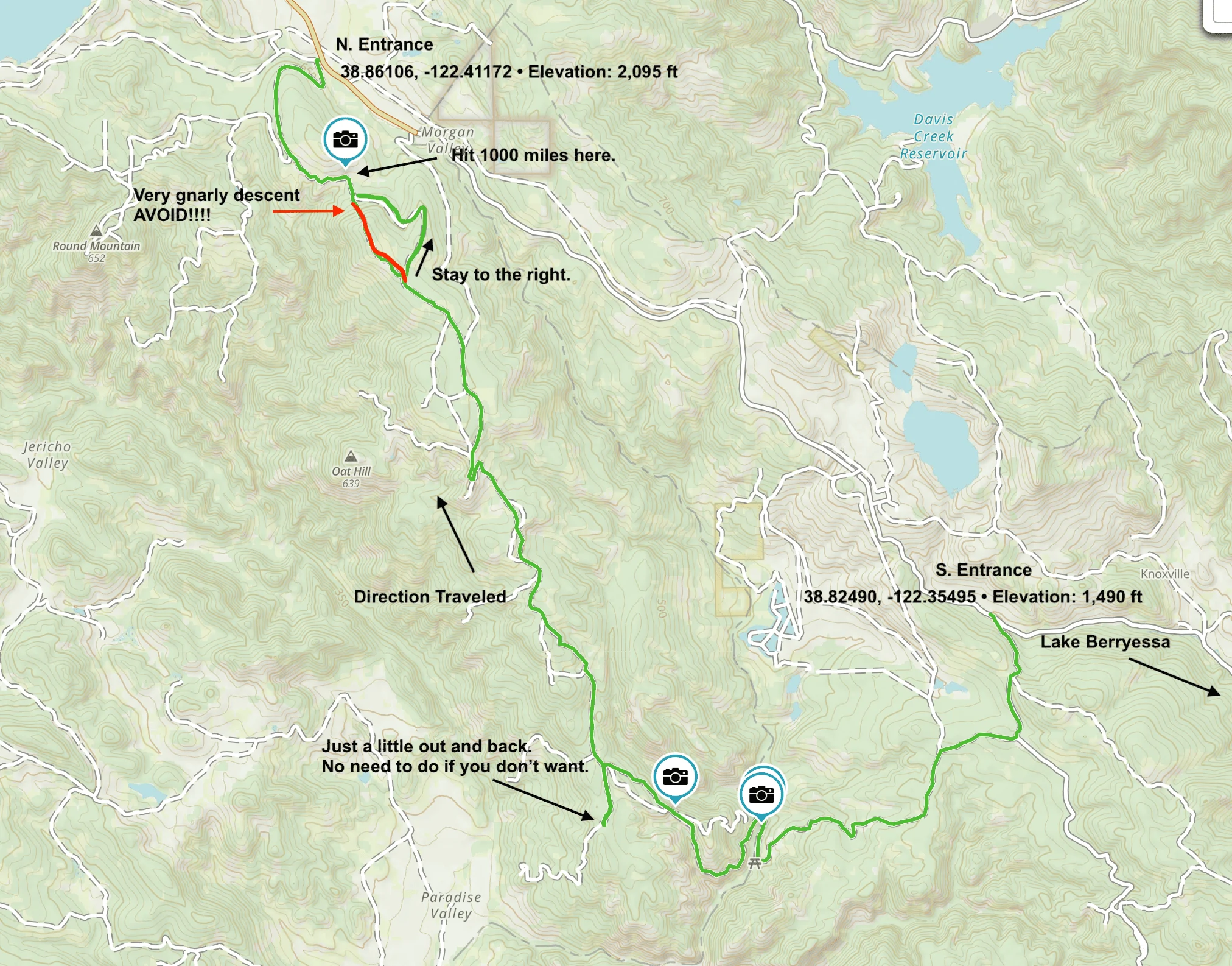
Below is a screenshot of the route we took with some info. I hope you find it useful. Please, PLEASE! note the upper part of the map where it says to stay to the right. Do it. Do NOT go the red route! Knoxville OHV doesn't rate their trails like other OHV parks. Green for easy, blue moderate, etc. The trail up to the point of the fork in the road had been relatively easy for us. We decided to go left, over the hill. Everything was fine till we got to the top. Lets just say it was the most challenging descent either one of us had ever taken. It required a lot of spotting and finesse. Probably took an hour to get down and I am amazed, AMAZED Gigi (that is my Bronco) made it out unscathed. Hind sight we should have turned around at the top, but it was also very exhilarating in both a good and bad way. The kicker though...the junction where it meets the other trail around the hill was ROPED OFF! What!? Uhhh..no sign, nothing indicating this from the other direction. Luckily we were able to go around the obstacle. After that we had to take a breath and check our pants. All good. Then we noticed...1000.0 mile mark. She is broken in!
Useful links:
Knoxville BLM website https://www.blm.gov/visit/knoxville
Our route via Gaia https://www.gaiagps.com/public/AYIXL6SPm6oFCnVExqNiJj4C/?layer=GaiaTopoRasterMeters&slideshow=false
Here is a link to the .gpx file of the route https://www.dropbox.com/s/x2o04jds8vvsmi8/The_break_in_of_the_Bronco.gpx?dl=0
Here is a link to a free online .gpx viewer https://www.viewgpx.com
Hope you find this post useful.
Our Route:

Thursday my friend and I decided to do a boondoggle (aka playing hooky) and took my Bronco for her first day off-road. Here is a summary of our trip. We used my friends Gaia app to record the trip.
It is about a 2 hour drive from Walnut Creek and we went via Lake Berryessa. It was a nice drive but there is still a lot of fire damage that you can see. Slightly after the lake, the two lane road really turns into a country road with a lot of pot holes and some stream crossings. The stream crossings have a concrete base and I bet can be quite large if there is a lot of rain. There was water but not much.
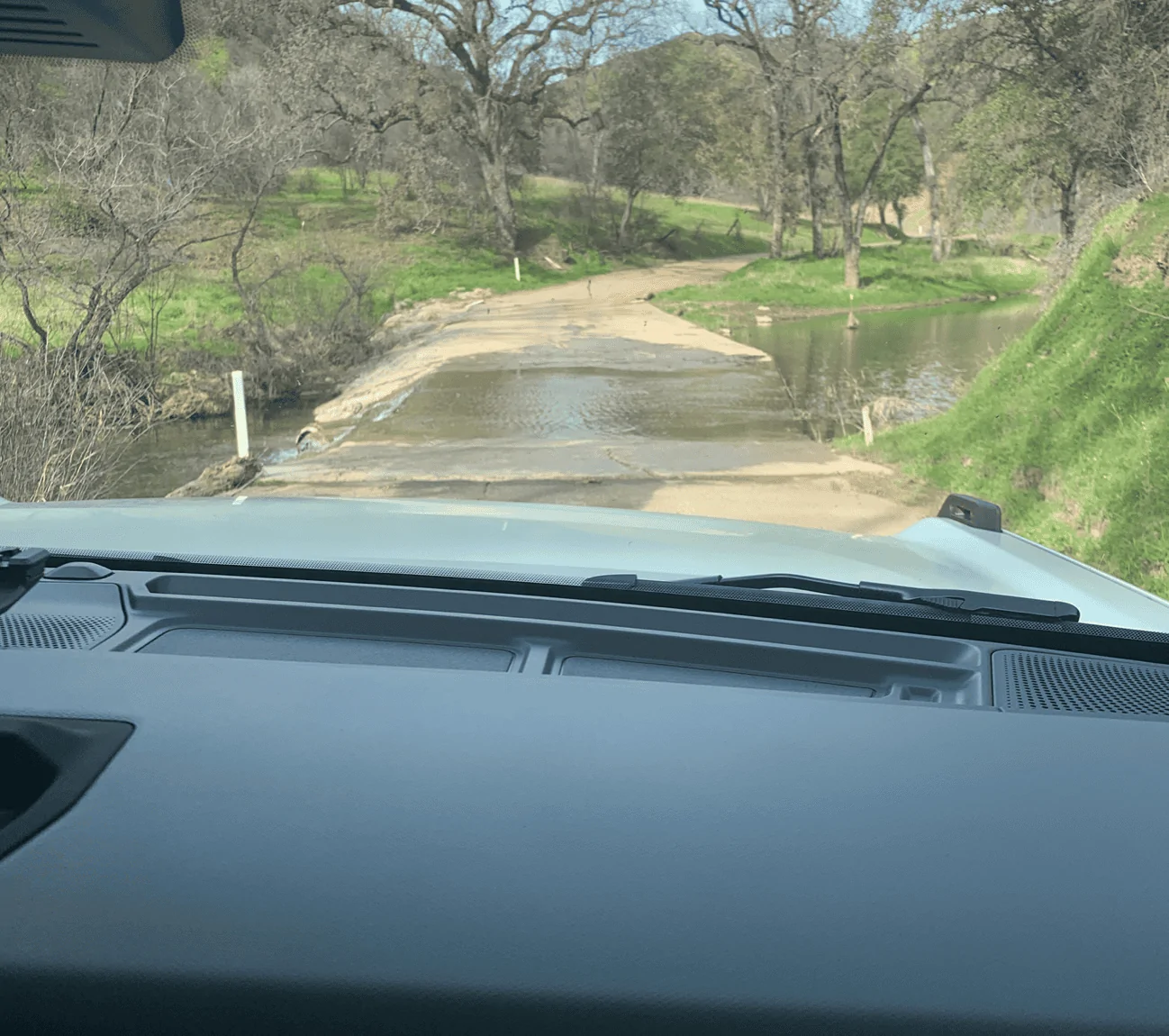
We drove past the south entrance a bit just to check it out and then looped back to go in on the south entrance and out of the north entrance. Drove up a small hill and aired down. Make sure you have a good air compressor. I have this one from Viair https://www.viaircorp.com/portables/400p-auto Aired down to 20 psi via gauge on compressor but car TPMS said 23-25. I usually like to go lower around 18 but didn't think it necessary.
I think this is a good starter trail. One of the reasons we wanted to do it was to flesh out the Bronco and not have too much of a challenge her first time out. The route we took has enough challenges that those new to off-roading will have fun but still need to think and plan your line. Just take it slow and easy when you meet a challenge for you and your Bronco will perform well. In the beginning of the trail I was in 2H. However, I did switch to 4H eventually. I also wanted to make sure the Bronco didn't have any issues so I also tried all the features (hero switches and trail "cruise control") and everything worked fine. There are some open areas where you can push the Bronco a little faster and that was fun. Of course, the terrain can change because of weather so this is no guarantee there won't be more or less challenges on the route we took. Read...do it at your own risk.
Below is a screenshot of the route we took with some info. I hope you find it useful. Please, PLEASE! note the upper part of the map where it says to stay to the right. Do it. Do NOT go the red route! Knoxville OHV doesn't rate their trails like other OHV parks. Green for easy, blue moderate, etc. The trail up to the point of the fork in the road had been relatively easy for us. We decided to go left, over the hill. Everything was fine till we got to the top. Lets just say it was the most challenging descent either one of us had ever taken. It required a lot of spotting and finesse. Probably took an hour to get down and I am amazed, AMAZED Gigi (that is my Bronco) made it out unscathed. Hind sight we should have turned around at the top, but it was also very exhilarating in both a good and bad way. The kicker though...the junction where it meets the other trail around the hill was ROPED OFF! What!? Uhhh..no sign, nothing indicating this from the other direction. Luckily we were able to go around the obstacle. After that we had to take a breath and check our pants. All good. Then we noticed...1000.0 mile mark. She is broken in!
Useful links:
Knoxville BLM website https://www.blm.gov/visit/knoxville
Our route via Gaia https://www.gaiagps.com/public/AYIXL6SPm6oFCnVExqNiJj4C/?layer=GaiaTopoRasterMeters&slideshow=false
Here is a link to the .gpx file of the route https://www.dropbox.com/s/x2o04jds8vvsmi8/The_break_in_of_the_Bronco.gpx?dl=0
Here is a link to a free online .gpx viewer https://www.viewgpx.com
Hope you find this post useful.
Our Route:
Show full message↓